LANDSCAPES
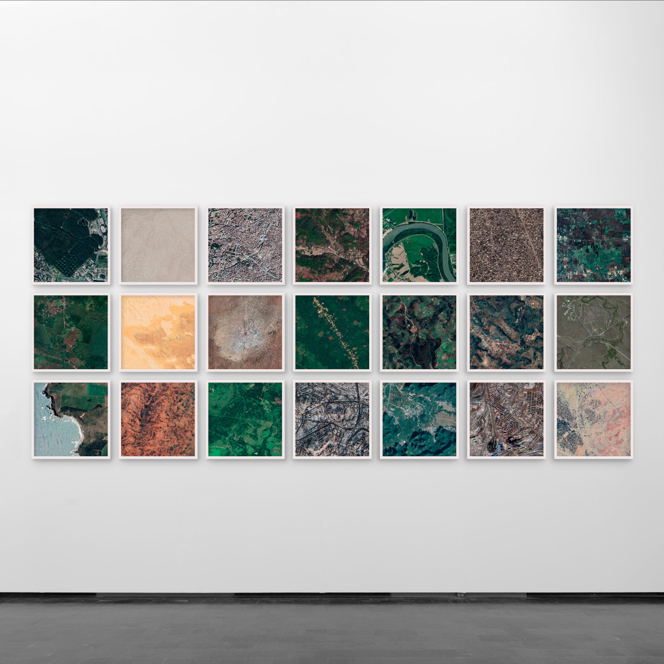
Landscapes is a series of 21 satellite images of crime scenes of different genocides and comparable events of the 20th century from different regions of the world. Each image covers exactly the same area and is representative of larger events in the context of which the respective crimes occurred. Each crime scene and image is representative of larger events in which context the respective crimes occurred.
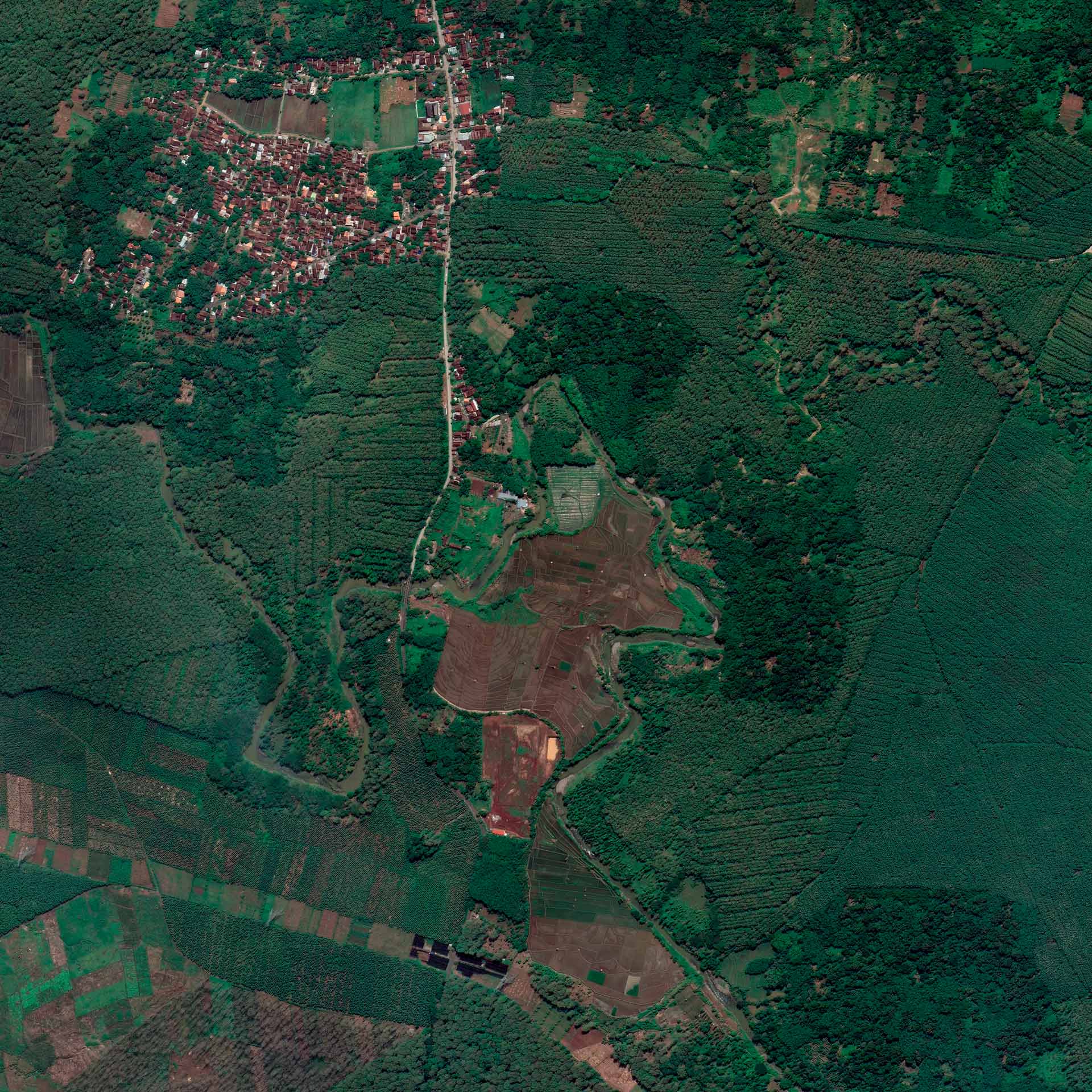
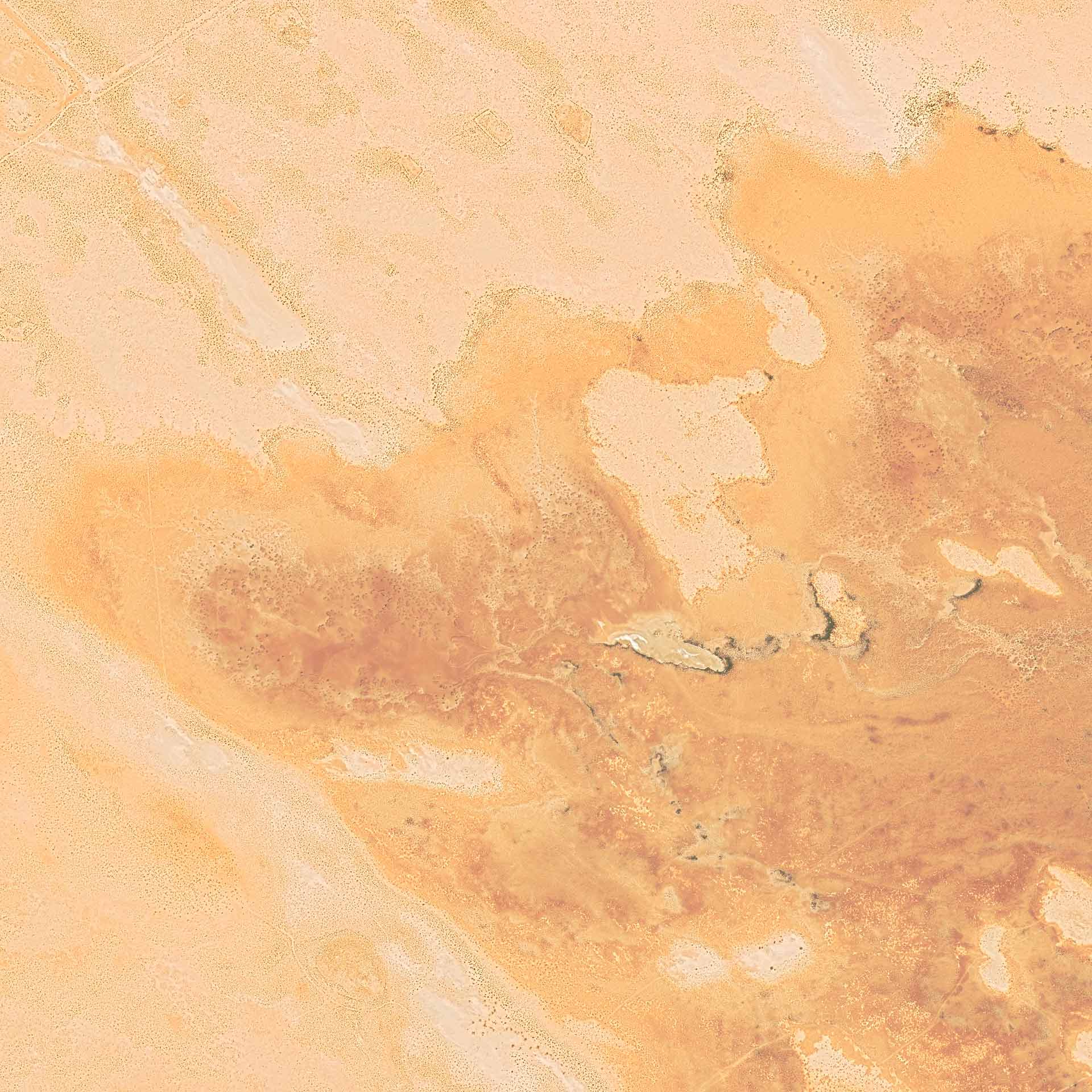
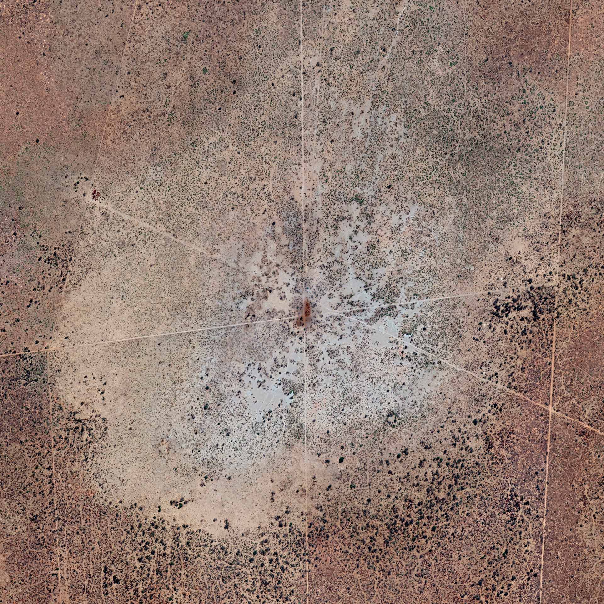
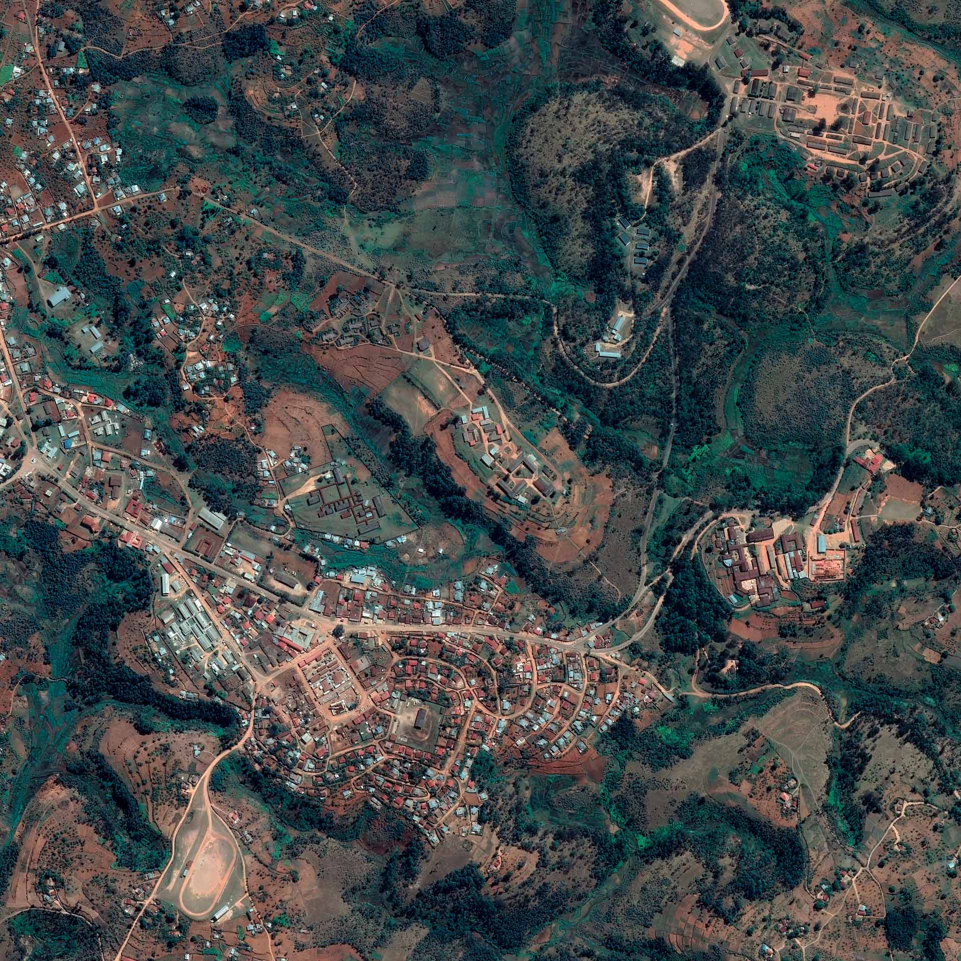
The strictly technical method of capturing the images from the extreme distance of space ensures a maximum of objectivity. Any attempt at artistic composition is avoided. Unintentionally, however, the locations change their character through the direct overhead perspective from the air, and images with aesthetic qualities are created. At the same time, nothing reminds of the tragic stories of the places.
The work reflects the attempt and the failure to approach incredible events, such as genocides. Even the greatest possible objectivity does not make what happened understandable. By juxtaposing different events from all over the world with very different backgrounds, but also decisive commonalities, the universality of the topic is shown.
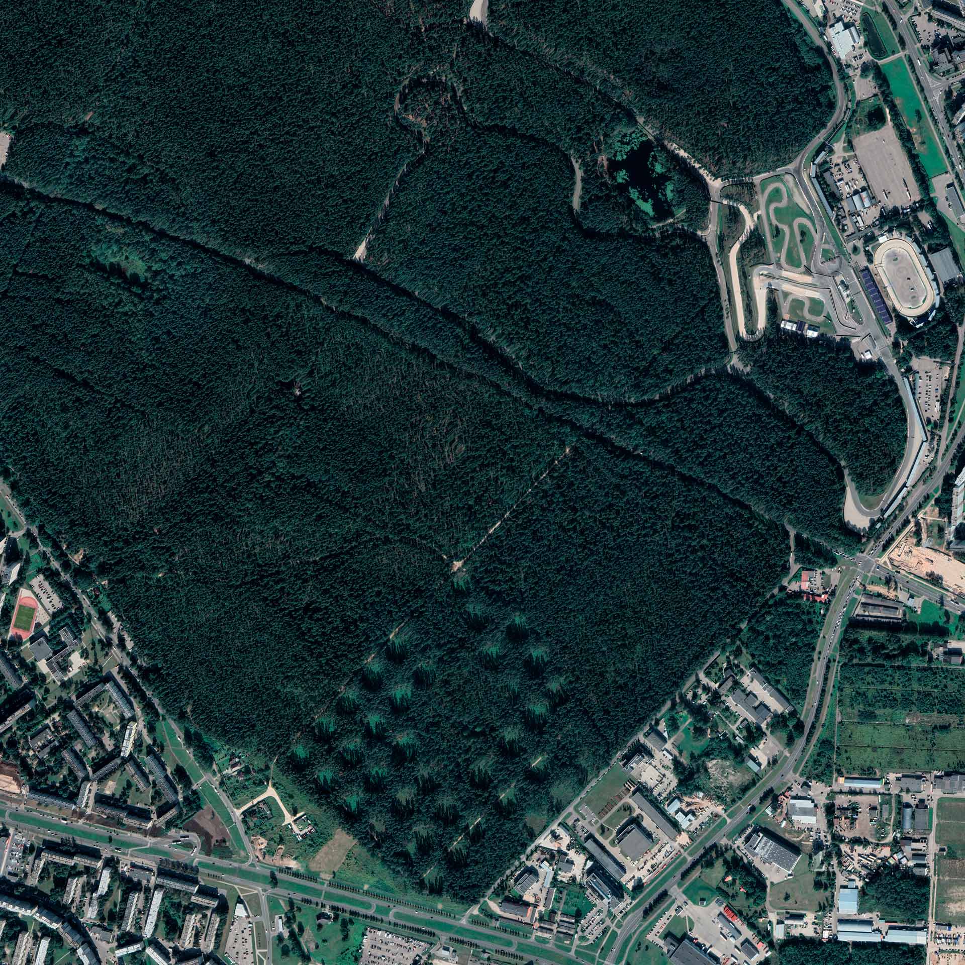
LANDSCAPE 1
Coordinates
56°57′46.7″N, 24°12′37.2″E
Location
Biķernieki Woods, Riga, Latvia
Date
06/01/1941–10/30/1944
Victims
Jews, war prisoners, resistors
Perpetrators
Sicherheitspolizei, Latvian auxiliary
Deaths
35,000 – 46,500
Coordinates
56°57′46.7″N, 24°12′37.2″E
Location
Biķernieki Woods, Riga, Latvia
Date
06/01/1941–10/30/1944
Victims
Jews, war prisoners, resistors
Perpetrators
Sicherheitspolizei, Latvian auxiliary
Deaths
35,000 – 46,500

LANDSCAPE 2
Coordinates
35°31'44.15"N, 40° 9'3.33"E
Location
Governorate Deir ez-Zor, Syria
Date
1915 – 1916
Victims
Armenians
Perpetrators
Security forces, Military of the Ottoman Empire
Deaths
up to 150,000
Coordinates
35°31'44.15"N, 40° 9'3.33"E
Location
Governorate Deir ez-Zor, Syria
Date
1915 – 1916
Victims
Armenians
Perpetrators
Security forces, Military of the Ottoman Empire
Deaths
up to 150,000
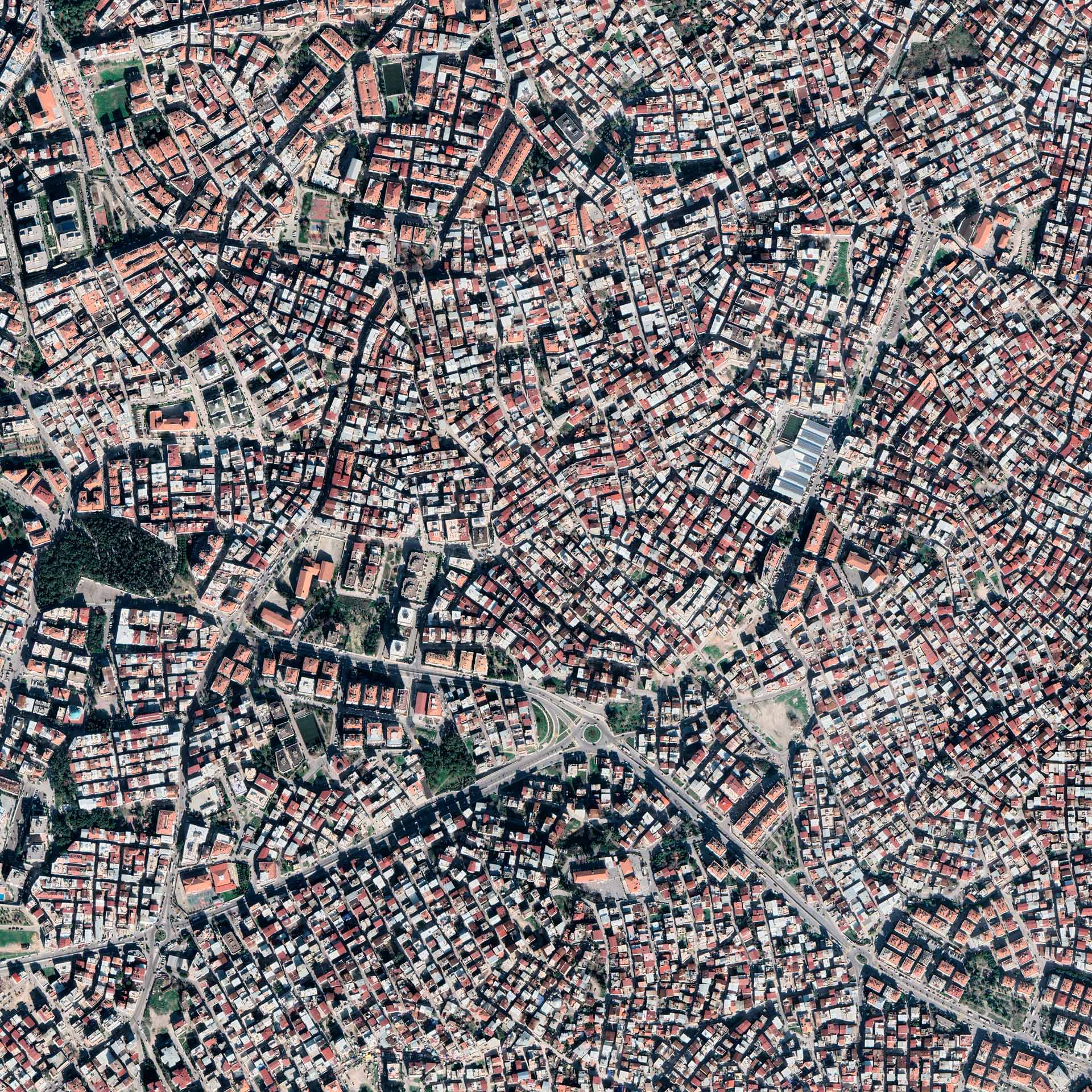
LANDSCAPE 3
Coordinates
44°13'0"N, 19°12'0"E
Location
Izmir city area, Izmir, Turkey
Date
09/13/1922 – 09/02/1922
Victims
Greeks, Armenians
Perpetrators
Military of the Ottoman Empire
Deaths
10,000 – 125,000
Coordinates
44°13'0"N, 19°12'0"E
Location
Izmir city area, Izmir, Turkey
Date
09/13/1922 – 09/02/1922
Victims
Greeks, Armenians
Perpetrators
Military of the Ottoman Empire
Deaths
10,000 – 125,000

LANDSCAPE 4
Coordinates
38°23'7.61"N, 27°7'10.63"E
Location
Kravica, Bratunac, Republika Srpska, Bosnia and Herzegovina
Date
07/14/1995
Victims
Bosnian males
Perpetrators
Army of the Republika Srpska
Deaths
1,000 – 1,500
Coordinates
38°23'7.61"N, 27°7'10.63"E
Location
Kravica, Bratunac, Republika Srpska, Bosnia and Herzegovina
Date
07/14/1995
Victims
Bosnian males
Perpetrators
Army of the Republika Srpska
Deaths
1,000 – 1,500

LANDSCAPE 5
Coordinates
45°15'57.65"N, 16°55'53.51"E
Location
Donja Gradina area, Kozarska Dubica, Republika Srpska, Bosnia and Herzegovina
Date
1941 – 1945
Victims
Mainly Serbs, also Jews, Roma,opponents of the regime, including Croats and Bosnian Muslims
Perpetrators
Ustasha forces
Deaths
80,000 – 400,000
Coordinates
45°15'57.65"N, 16°55'53.51"E
Location
Donja Gradina area, Kozarska Dubica, Republika Srpska, Bosnia and Herzegovina
Date
1941 – 1945
Victims
Mainly Serbs, also Jews, Roma,opponents of the regime, including Croats and Bosnian Muslims
Perpetrators
Ustasha forces
Deaths
80,000 – 400,000

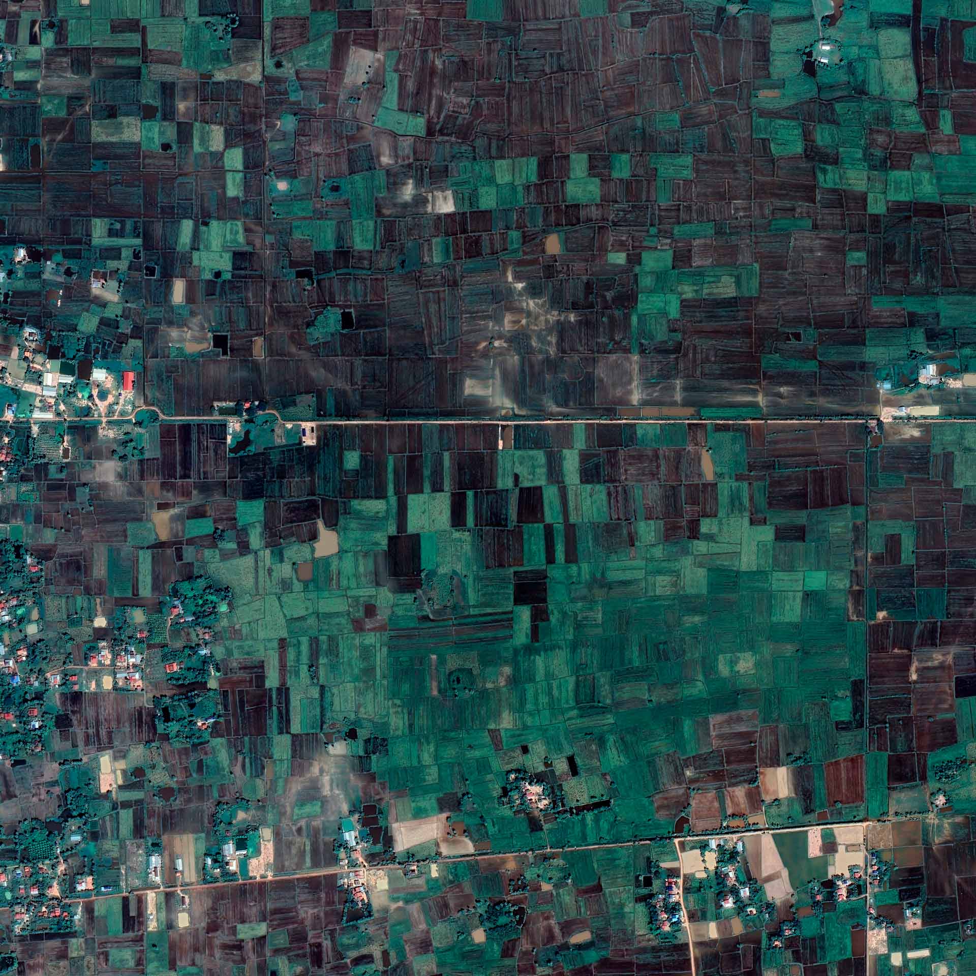
LANDSCAPE 6
Coordinates
Borough Mirpur, Dhaka, Bangladesh
Location
Biķernieki Woods, Riga, Latvia
Date
12/14/1971
Victims
Bengali intellectuals
Perpetrators
Pakistan Armed Forces, local collaborators
Deaths
min. 200
Coordinates
Borough Mirpur, Dhaka, Bangladesh
Location
Biķernieki Woods, Riga, Latvia
Date
12/14/1971
Victims
Bengali intellectuals
Perpetrators
Pakistan Armed Forces, local collaborators
Deaths
min. 200
LANDSCAPE 7
Coordinates
10°50'51.92"N, 104°39'36.63"E
Location
Angkor Chey District, Kampot, Kambodscha
Date
1975 – 1979
Victims
Khmer, Vietnamese, Muslim Cham minorities
Perpetrators
Pol Pot Regime Forces
Deaths
approx. 30,000
Coordinates
10°50'51.92"N, 104°39'36.63"E
Location
Angkor Chey District, Kampot, Kambodscha
Date
1975 – 1979
Victims
Khmer, Vietnamese, Muslim Cham minorities
Perpetrators
Pol Pot Regime Forces
Deaths
approx. 30,000
LANDSCAPE 8
Coordinates
7° 0'21.43"S, 110°15'47.87"E
Location
Plumbon area, Java, Indonesia
Date
Dec 1965 – Jan 1966
Victims
Indonesians
Perpetrators
Indonesian Army, special militias
Deaths
approx. 24
Coordinates
7° 0'21.43"S, 110°15'47.87"E
Location
Plumbon area, Java, Indonesia
Date
Dec 1965 – Jan 1966
Victims
Indonesians
Perpetrators
Indonesian Army, special militias
Deaths
approx. 24
LANDSCAPE 9
Coordinates
30°14'54.30"N, 19°33'0.17"E
Location
El-Agheila area, Cyrenaica, Libya
Date
Jan 1930 – Oct 1932
Victims
Cyrenean population
Perpetrators
Italian Armed Forces, Eritrean Askari, colonial police
Deaths
approx. 15,600
Coordinates
30°14'54.30"N, 19°33'0.17"E
Location
El-Agheila area, Cyrenaica, Libya
Date
Jan 1930 – Oct 1932
Victims
Cyrenean population
Perpetrators
Italian Armed Forces, Eritrean Askari, colonial police
Deaths
approx. 15,600
LANDSCAPE 10
Coordinates
21°43'41.70"S, 19° 5'47.17"E
Location
Omaheke region, Namibia
Date
1904 – 1908
Victims
Herero
Perpetrators
Schutztruppe
Deaths
24,000 – 100,000
Coordinates
21°43'41.70"S, 19° 5'47.17"E
Location
Omaheke region, Namibia
Date
1904 – 1908
Victims
Herero
Perpetrators
Schutztruppe
Deaths
24,000 – 100,000

LANDSCAPE 11
Coordinates
0°26'32.99"N, 21°55'42.84"E
Location
Bolima area, Tshuapa, Democratic Republic of the Congo
Date
1888 – 1908
Victims
Congolese
Perpetrators
Congolese support staff of Belgian concessionary companies
Deaths
10 – 20
Coordinates
0°26'32.99"N, 21°55'42.84"E
Location
Bolima area, Tshuapa, Democratic Republic of the Congo
Date
1888 – 1908
Victims
Congolese
Perpetrators
Congolese support staff of Belgian concessionary companies
Deaths
10 – 20

LANDSCAPE 12
Coordinates
2°11'31.16"S, 29°20'26.89"E
Location
Bisesero area, Western Rwanda
Date
Apr 1994 – Jun 1994
Victims
Tutsi
Perpetrators
Various Hutu members
Deaths
40,000
Coordinates
2°11'31.16"S, 29°20'26.89"E
Location
Bisesero area, Western Rwanda
Date
Apr 1994 – Jun 1994
Victims
Tutsi
Perpetrators
Various Hutu members
Deaths
40,000
LANDSCAPE 13
Coordinates
3°56'55.43"S, 29°37'30.79"E
Location
Bururi Province, Bururi, Burundi
Date
Apr 1972
Victims
Hutus, mainly elite, Tutsi Banyaruguru
Perpetrators
Army of Burundi
Deaths
up to 100,000
Coordinates
3°56'55.43"S, 29°37'30.79"E
Location
Bururi Province, Bururi, Burundi
Date
Apr 1972
Victims
Hutus, mainly elite, Tutsi Banyaruguru
Perpetrators
Army of Burundi
Deaths
up to 100,000

LANDSCAPE 14
Coordinates
43° 8'32.84"N, 102°21'54.39"W
Location
Wounded Knee area, South Dakota, United States of America
Date
12/29/1890
Victims
Members of various Sioux tribes
Perpetrators
7th U.S. Cavalry Regiment
Deaths
150 – 300
Coordinates
43° 8'32.84"N, 102°21'54.39"W
Location
Wounded Knee area, South Dakota, United States of America
Date
12/29/1890
Victims
Members of various Sioux tribes
Perpetrators
7th U.S. Cavalry Regiment
Deaths
150 – 300

LANDSCAPE 15
Coordinates
40°40'60.00"S, 144°40'60.00"E
Location
Cliffs on Cape Grim Peninsula, Tasmania, Australia
Date
02/10/1828
Victims
Tasmanian Aborigines of the Pennemukeer clan
Perpetrators
British colonialists
Deaths
30
Coordinates
40°40'60.00"S, 144°40'60.00"E
Location
Cliffs on Cape Grim Peninsula, Tasmania, Australia
Date
02/10/1828
Victims
Tasmanian Aborigines of the Pennemukeer clan
Perpetrators
British colonialists
Deaths
30

LANDSCAPE 16
Coordinates
22° 6'26.93"S, 132°29'14.59"E
Location
surroundings of the Coniston cattle station, Northern Territory, Australia
Date
Aug 1928
Victims
Members of the Warlpiri, Anmatyerre and Kaytetye ethnic groups
Perpetrators
The police rider Constable William Murray, the settler Nugget Morton
Deaths
31 – 110

LANDSCAPE 17
Coordinates
57° 0'58.03"N, 29°23'30.37"E
Location
Novorzhev area, Pskov Oblast, Russian Federation
Date
06/06/1942
Victims
Roma
Perpetrators
Wehrmacht Sicherungsdivision
Deaths
128
Coordinates
57° 0'58.03"N, 29°23'30.37"E
Location
Novorzhev area, Pskov Oblast, Russian Federation
Date
06/06/1942
Victims
Roma
Perpetrators
Wehrmacht Sicherungsdivision
Deaths
128

LANDSCAPE 18
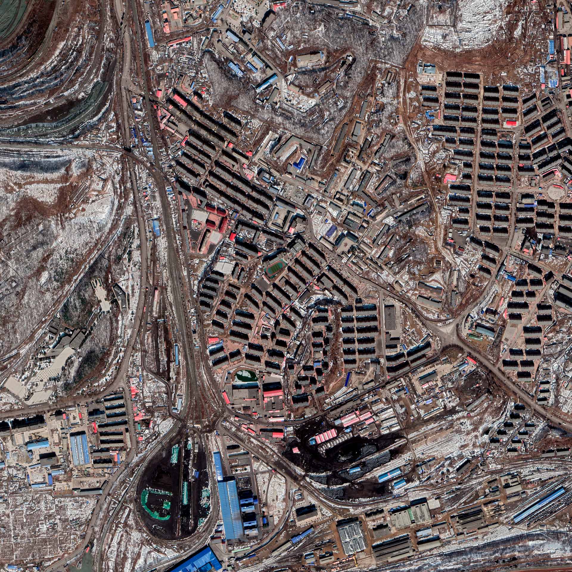
Coordinates
43° 8'5.88"N, 131°53'43.38"E
Location
Vladivostok area, Far Eastern Federal District, Russian Federation
Date
1937
Victims
Korjo-Saram, a variety of other ethnic groups
Perpetrators
NKVD
Deaths
350,000 – 365,000
Coordinates
43° 8'5.88"N, 131°53'43.38"E
Location
Vladivostok area, Far Eastern Federal District, Russian Federation
Date
1937
Victims
Korjo-Saram, a variety of other ethnic groups
Perpetrators
NKVD
Deaths
350,000 – 365,000

LANDSCAPE 19
Coordinates
23°32'52.54"N, 109°39'12.65"E
Location
Wuxuan County, People's Republic of China
Date
1966 – 1976
Victims
Chinese
Perpetrators
People's Liberation Army, ordinary citizens
Deaths
100,000 – 150,000
Coordinates
23°32'52.54"N, 109°39'12.65"E
Location
Wuxuan County, People's Republic of China
Date
1966 – 1976
Victims
Chinese
Perpetrators
People's Liberation Army, ordinary citizens
Deaths
100,000 – 150,000
LANDSCAPE 20
Coordinates
41°50'2.48"N, 123°55'32.85"E
Location
Quarter Pingdingshan, Fushun, Liaoning, People's Republic of China
Date
09/15/1932
Victims
Chinese
Perpetrators
Imperial Japanese Army, police forces
Deaths
min. 3,000
Coordinates
41°50'2.48"N, 123°55'32.85"E
Location
Quarter Pingdingshan, Fushun, Liaoning, People's Republic of China
Date
09/15/1932
Victims
Chinese
Perpetrators
Imperial Japanese Army, police forces
Deaths
min. 3,000

LANDSCAPE 21
Coordinates
14°14'12.96"N, 24°39'46.23"E
Location
Kutum area, North Darfur, Sudan
Date
12/02/15 – 12/04/15
Victims
mainly members of the Zaghawa ethnic group
Perpetrators
Janjaweed militia, paramilitary units
Deaths
approx. 9
Coordinates
14°14'12.96"N, 24°39'46.23"E
Location
Kutum area, North Darfur, Sudan
Date
12/02/15 – 12/04/15
Victims
mainly members of the Zaghawa ethnic group
Perpetrators
Janjaweed militia, paramilitary units
Deaths
approx. 9